The Oldest World Map

World map 6th century BC. It is thought to be the world oldest map. It shows Babylon, Euphrates, surrounded by circular landmass with Assyria, Armenia, Ocean and seven Islands arranged around it to form a seven-pointed star.
Turkocentric World Map 11th Century

World map of Mahmud al-Kashgari of Turks. This map oriented with east on the top, showing Taklamakan and the Altai in the centre, the Caspian Sea to the north, Iraq, Azerbaijan, Yemen and Egypt to the the west, China and Japan to the east, Hindustan, Kashmir, Gog and Magog to the south. The world is shown as encircled by the ocean.
12th Century

World map from the Italian monk Beato di Liebana, made in the 12th century.
14th Century

World map made around 1420 by the Italian cartographer Pietro Vesconte.

World map of the German cartographer Andreas Walsperger made in 1448.
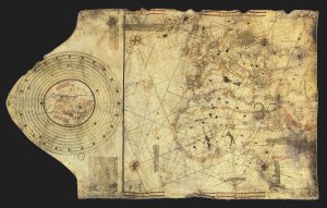
Colombus Map 15th Century

The “Columbus map” which perhaps was drawn by Christopher Columbus and his brother Bartolomeo in Lisbon around 1490 before the discovery of the New World, showing the known world in their time.
Early 16th Century

Year of 1500, map of Juan de la Cosa, Spanish cartographer, conquistador and explorer who sailed the first 3 voyages with Columbus.
Later in 16th Century

Scottish cartographer Johne Rotz, published 1542 in the Boke of Idrography.
Second Half of 17th Century

Dutch cartographer Claes Janszoon Visscher in 1652
18 Century

Map of 18 century looks pretty much like modern map. This map was done by German geographer and cartographer Johann Baptist Homann.
19 Century

Dutch world map from Otto Petri 1860

World map 6th century BC. It is thought to be the world oldest map. It shows Babylon, Euphrates, surrounded by circular landmass with Assyria, Armenia, Ocean and seven Islands arranged around it to form a seven-pointed star.
Turkocentric World Map 11th Century

World map of Mahmud al-Kashgari of Turks. This map oriented with east on the top, showing Taklamakan and the Altai in the centre, the Caspian Sea to the north, Iraq, Azerbaijan, Yemen and Egypt to the the west, China and Japan to the east, Hindustan, Kashmir, Gog and Magog to the south. The world is shown as encircled by the ocean.
12th Century

World map from the Italian monk Beato di Liebana, made in the 12th century.
14th Century

World map made around 1420 by the Italian cartographer Pietro Vesconte.

World map of the German cartographer Andreas Walsperger made in 1448.
Colombus Map 15th Century

The “Columbus map” which perhaps was drawn by Christopher Columbus and his brother Bartolomeo in Lisbon around 1490 before the discovery of the New World, showing the known world in their time.
Early 16th Century

Year of 1500, map of Juan de la Cosa, Spanish cartographer, conquistador and explorer who sailed the first 3 voyages with Columbus.
Later in 16th Century

Scottish cartographer Johne Rotz, published 1542 in the Boke of Idrography.
Second Half of 17th Century

Dutch cartographer Claes Janszoon Visscher in 1652
18 Century

Map of 18 century looks pretty much like modern map. This map was done by German geographer and cartographer Johann Baptist Homann.
19 Century

Dutch world map from Otto Petri 1860
No comments:
Post a Comment